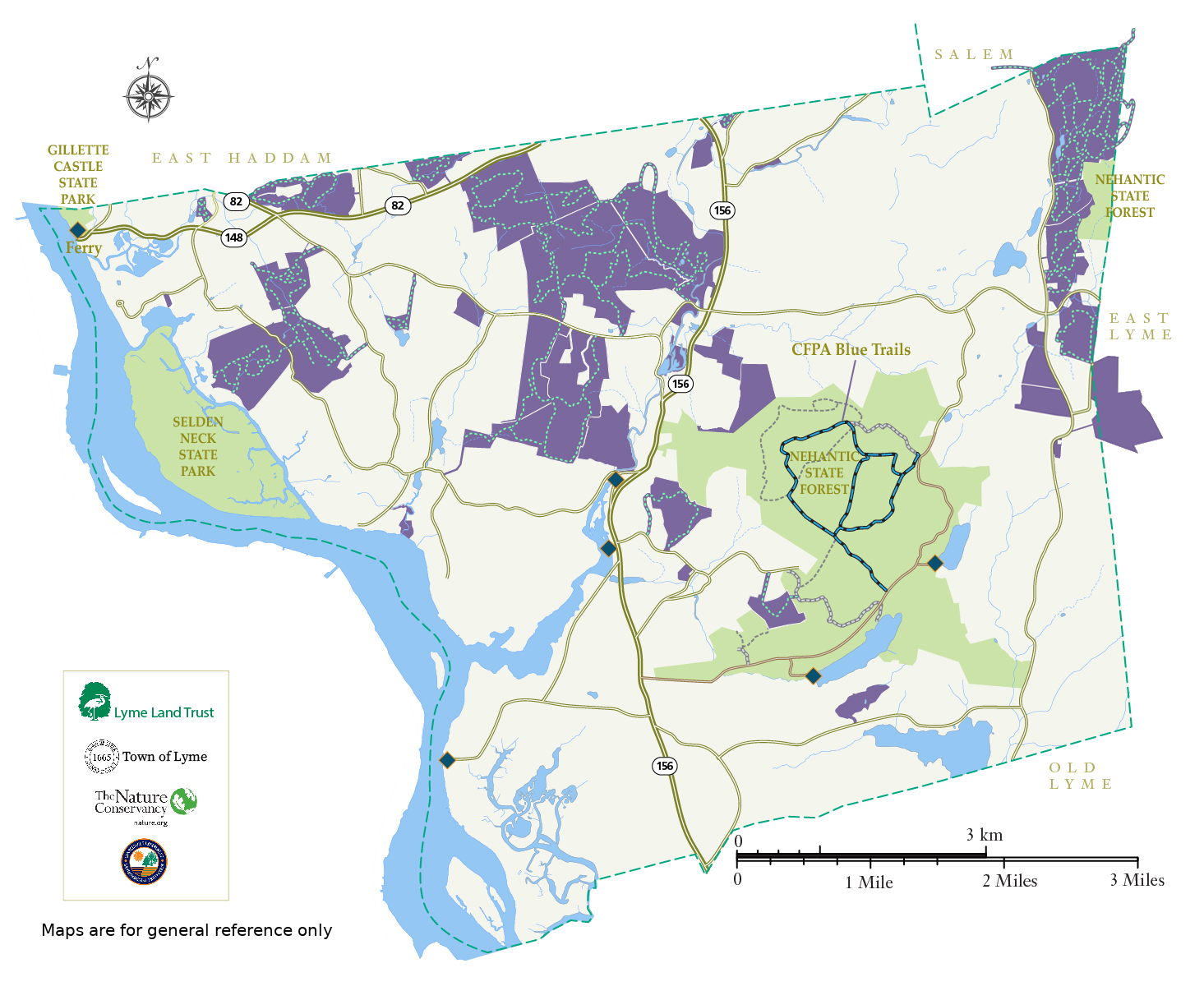
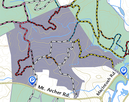
River to Ridgetop South
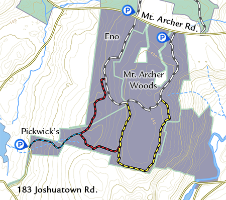
River to Ridgetop South: Mt. Archer Woods, Eno, and Pickwick’s Preserve; 398 acres. Trails: 4.8 miles. These adjacent preserves are located south of Mt. Archer Rd.
Parking: Parking lot at Mt. Archer Woods, Mt. Archer Rd.
Detailed Trail Map and brochure. Part of River to Ridgetop Preserves: Map of entire region..
Description: Even though these preserves are on top of Mt. Archer, one of the highest hills in Lyme, the trails are mostly flat and easy, with a few rocky, seasonal wet areas. The trails pass historical ruins and afford seasonal views of the CT River. Non-motorized bicycles and horses are allowed on the white and yellow trails.
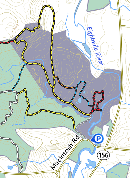
River to Ridgetop North
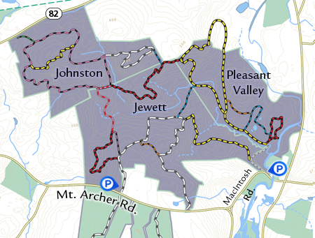
River to Ridgetop North: Pleasant Valley, Jewett, Johnston Preserve. 920 acres.
Trails: 13.5 miles (13 trails) These adjacent preserves are located north of Mt. Archer Rd.
Parking: Pull-in lot, MacIntosh Rd.; Jewett cemetery entrance, Mt Archer Rd.; and Johnston parking lot, Rte. 82.
Detailed Trail Map and brochure. Part of River to Ridgetop Preserves: Map of entire regioun..
Description: With the River to Ridgetop South Preserves, these scenic preserves share a network of more than 18 miles of trails and 1314 acres. One can hike through the woods on the complex of trails from Joshuatown Rd. or McIntosh Rd. to Rte. 82, passing through diverse habitats and lingering to view stunning overlooks.
Hadlyme Hills
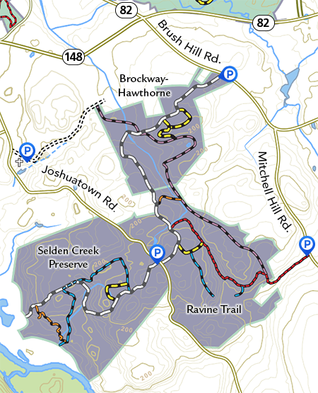
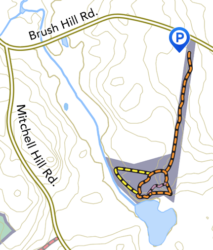
Hadlyme Hills: Brockway-Hawthorne Preserve, Ravine Trail, and Selden Creek Preserve; 476 acres. Trail Network: 6.5 miles.
Parking: Brush Hill Rd., Joshuatown Rd. (4 miles from Rte. 156), Selden Cemetery. Joshuatown Rd., and Mitchell Hill Rd.
Detailed Trail map and brochure.
Description: This unique network of trails traverses an amazing variety of vibrant natural habitats, from overlooks of tidal marches on Selden Creek, through deep ravines to a forested woodland brook wetland. The three contiguous preserves together create a valuable corridor for wildlife species and protect vital watershed resources. From the Brush Hill Rd. parking lot, you can walk a 4-mile round-trip on the white trail through the three preserves to the overlook at Selden Creek and back.
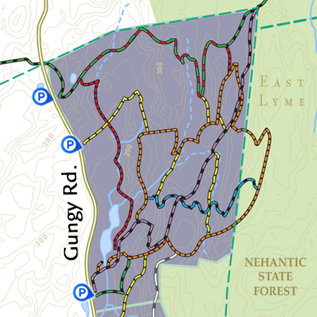
Lyme Corner Trails
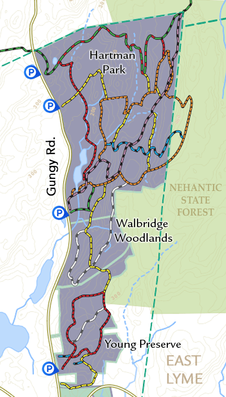
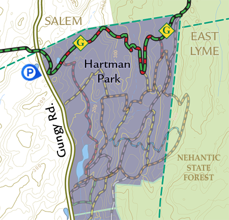
Lyme Corner Trails: Hartman Park, Walbridge Woodlands & Philip E. Young Preserve: 422 acres. Trail network: 12 miles (8 trails, 7 connectors, 2 spurs).
Parking: Four parking areas on Gungy Rd., main Hartman Park entrance is for access to Hartman Park and Walbridge Woodlands.
Lyme Corner Trails map and brochure with interpretive trail.
Descriptions: These three adjacent preserves offer natural, archeological and geological sites of interest. The large expanse of open space, including adjacent parcels, is a valuable wildlife corridor. The Lyme Corner Trails cross properties that are owned and managed cooperatively by the Town of Lyme and the Lyme land Trust. Horses and non-motorized bicycles are allowed, except on the white trails.
Heritage Trail Booklet. A delightful self-guided interpretive tour of the Heritage Trail.
Walbridge Woodland
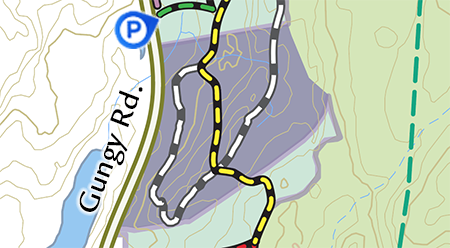
Walbridge Woodland: 46.4 acres. Trails: 1.25 miles (2 trails).
Parking: Hartman Park main parking entrance, Gungy Rd.
Lyme Corner Trails brochure and map.
Description: On the white trail is a cedar grove with a barn foundation. The grove is mowed every year to maintain the open field. The upper white trail follows a rocky ridge bordered by beautiful stone walls. Horses and non-motorized bicycles are allowed on yellow trail.
Hartman Park
Hartman Park: 302 acres. Trails: 9 miles (7 trails, 6 connectors).
Parking: East side of Gungy Rd.; main entrance, field entrance and Goodwin Trail parking.
Map for Family Walk/Scavenger Hunt
Lyme Corner Trails map and brochure with interpretive trail.
Description: The 3-mile orange Heritage Trail features archeological ruins. Beavers have been very active in the park and constantly alter the landscape and create new habitat, which attracts diverse birds and other wildlife. The red trail meanders along ridges and ledges and has some steep rocky areas. The fairy circle on the green trail is an easy, 1/4-mile round-trip walk to a kid-friendly destination. Non-motorized bikes and horses are allowed on all trails except the white.
Heritage Trail Booklet. A delightful self-guided interpretive tour of the Heritage Trail.
Cultural Resources in Hartman Park, a 1993 report by Dr, John Pfeiiffer
Young Preserve
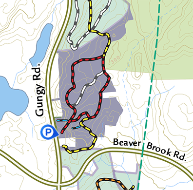
Philip E. Young Preserve: 82 acres. Trails: 1.5 miles (3 trails, 2 spurs).
Lyme Corner Trails brochure and map.
Parking: East side of Gungy Rd, about 1/2mile north of Beaver Brook Rd.
Description: The first 100 feet of the red trail is a steep rocky climb. A gentler approach can be found at the yellow trailhead, a short walk on the road to the south. Once at the top, the trails are mostly flat and easy with abundant mountain laurel and mature forest. Blue spur trails provide dramatic overlooks atop steep cliffs. Horses and non-motorized bikes are allowed on the red trail.
Beebe Preserve
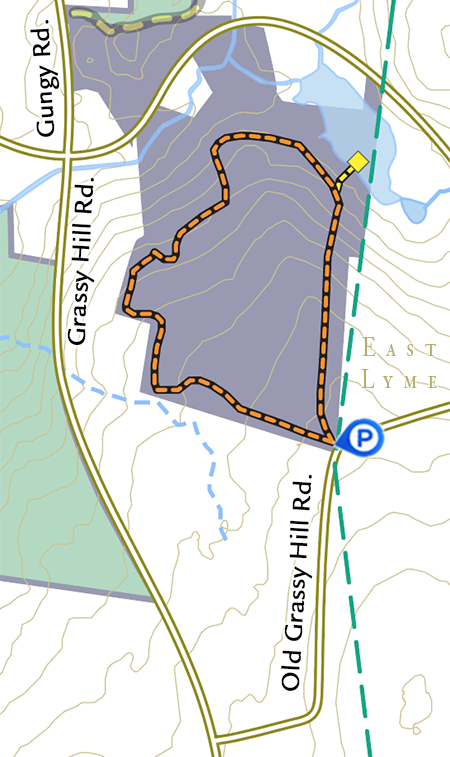
Beebe Preserve: 83 acres. Trails: 1-mile loop, (1 trail, 1 spur).
Parking: Parking lot on Old Grassy Hill Rd. near East Lyme border.
Detailed Trail Map and brochure.
Description: The easy one-mile orange trail loop leads hikers past old stone walls and a mysterious giant rock pile. Take yellow spur trail to a wildlife viewing platform with bench on a vibrant beaver pond.
Banningwood Preserve
Banningwood Preserve: 102 acres. Trails: 1.7 miles (2 trails).
Parking: 19 Town St. (Rte. 82), 1/4 mile north of Hadlyme Four Corners.
Banningwood Map and Self-guided Walk for All Ages
Detailed Banningwood Map and Self-guided Walk Geology and Ecology
Description: From the parking lot, the red trail 1-mile loop is an easy walk along Roaring Brook to Diana’s Field with picnic tables, then a climb to reach Parker’s Perch, a viewing platform on a dramatic rock outcrop in the Honey Hill Fault Zone. The yellow trail is an easy walk through verdant wetlands along Roaring Brook. The Preserve protects 3/4 miles of the brook.
- Comprehensive Natural Resources Inventory of Banningwood Preserve by Anthony Irving, forest ecologist and Ralph Lewis, geologist.
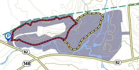
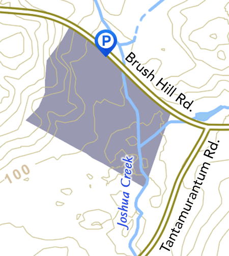
Brockway-Hawthorne Preserve
Brockway-Hawthorne Preserve: 82 acres. Trails: 2.5 miles (3 trails, 2 spurs).
Parking: lot on Brush Hill Rd. 1/2 mile south of Hadlyme Country Store, and at Selden Cemetery. Joshuatown Rd.
Detailed Trail map and brochure. Hadlyme Hills trail network.
Description: Trails meander along or across Whalebone Creek, past vernal pools and through live hemlock groves. For a delightful 0.8-mile round-trip walk through a Savannah-like open area with large old oak trees bordered by beautiful stone walls and an old abandoned quarry, from the Brush Hill Rd. parking lot take the white trail to a left on the yellow trail. Keep to the right to return.
Chestnut Hill Preserve
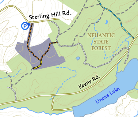
Chestnut Hill Preserve: 43 acres. Trails: 0.7 miles (1 trail, 1 spur).
Parking: along Sterling Hill Rd. The trail head is marked with a large sign.
Detailed Trail Map and brochure.
Descriptions: The orange trail plus a trail back through Nehantic State Forest provides a moderately easy 1-mile loop. Longer walk options are available on connecting Nehantic State Forest Trails.
Trail Map of Chestnut Hill with Nehantic State Forest. (Note the state map is not up-to-date. Use at your own risk.) Map needs updating
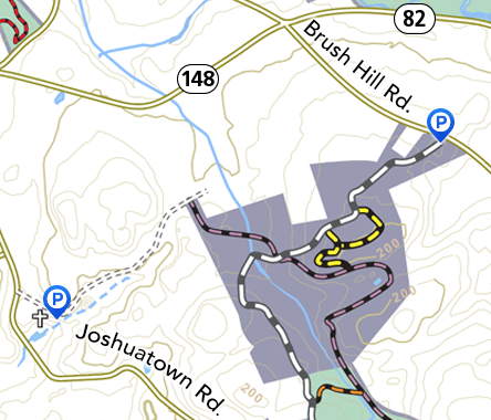
Thach Preserve
Thach Preserve: 13 acres. Trails: 1 mile (3 trails).
Parking: 131 Brush Hill Rd., short driveway to parking area.
Detailed Trail Map and brochure.
Description: This gem contains a variety of vibrant natural habitats in a 1-mile round trip walk over a rocky prominence to an active beaver pond that attracts an abundance of wildlife. A bench on an overlook and a picnic table by the beaver pond provide perfect picnic spots.
Clucas Preserve
Clucas Preserve: 24 acres. No Trails but visitors welcome.
Parking: Park near Clucas Field sign along Brush Hill Rd.
Description: The Clucas field is mostly a large open meadow that is mowed annually. Even though there are no trails in this preserve, you are welcome to wander the large field, walk along Joshua Brook and climb the wooded rock ledges. A good spot for birdwatching.
Grassy Hill Preserve
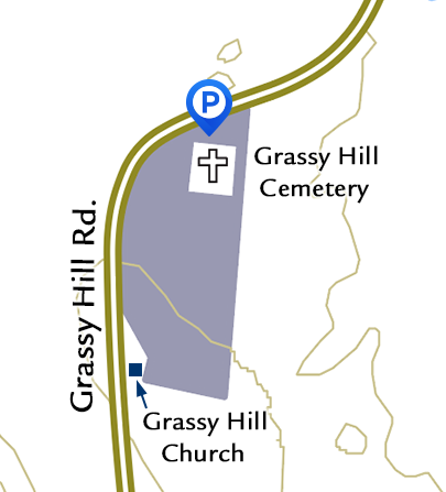
Grassy Hill Preserve: 4.26 acres. No trails.
Parking: entrance by the Grassy Hill Rd. Cemetery.
Description: Next to the historic Grassy Hill Congregational Church, this open field and wetland area provides important wildlife habitat. Guy Wiggin’s famous painting “Church on a Hill” was painted here in 1900 and is on display at the Lyman Allyn Art Museum in New London, CT.
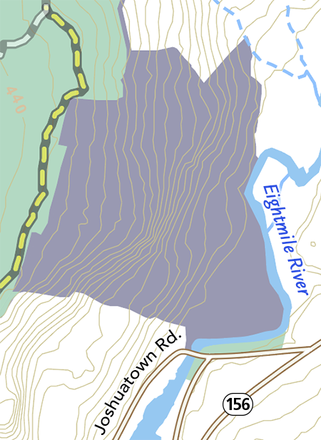
Eno Preserve / Pickwick's Preserve
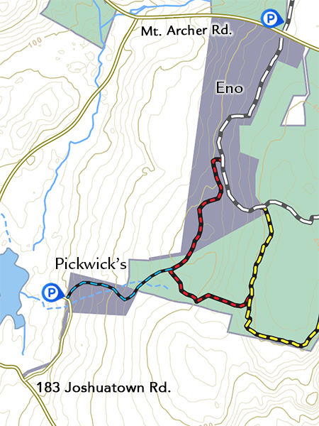
Eno Preserve: 101 acres. Trails 1.9 miles (2 trails)
Pickwick’s Preserve: private property with easement for 1.2-mile blue trail passage.
Parking: Jewett Preserve cemetery parking lot on the north side of Mt Archer Rd., and at 183 Joshuatown Rd. (Drive down the long driveway-park in front of the Pickwick’s Preserve sign.)
Detailed Trail Map and brochure. Part of River to Ridgetop Preserves: Map of entire region.
Description: Trails are moderately easy with some rocky, seasonally wet areas. There is an impressive stand of large tulip poplar trees on the white trail in Eno preserve.
Czikowsky Hill
Czikowsky Hill, 96 acres. No Trails
Parking: No designated parking.
This preserve is a wildlife sanctuary with no marked trails to minimize human disturbance.
Jewett Preserve
Jewett Preserve: 434 acres. Trails: 5.5 miles (6 trails).
Parking: Mt. Archer Rd. cemetery entrance, and pull-in lot on Macintosh Rd.
Detailed Trail Map and brochure. Part of River to Ridgetop Preserves: Map of entire region..
Description: The white trail, through mature forest with evidence of past human activity is a 2-mile loop with return on the road. Enjoy the red trail ridge walk with beautiful overlooks. Non-motorized biking and horses are allowed on the yellow, white and purple trails.
Mt. Archer Woods
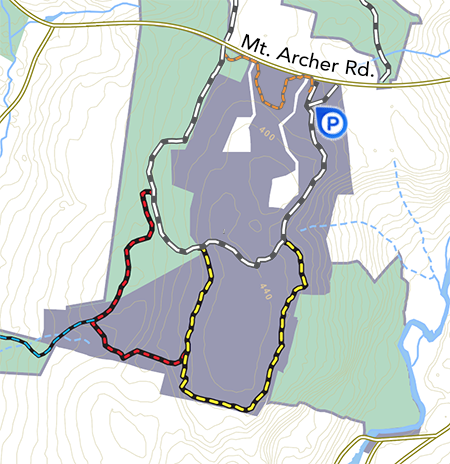
Mt. Archer Woods: 275 acres. Trails: 2.5 miles (3 trails).
Parking: Parking lot on South side of Mt Archer Rd.
Detailed Trail Map and brochure. Part of River to Ridgetop Preserves: Map of entire region.
Description: On top of Mt. Archer, one of the highest hills in Lyme, trails are mostly flat and easy. Ruins of an old Colonial farm on the white trail attest to historical use. This once-prime grazing land was abandoned more than a century ago and has now become a mature forest.
Patrell Preserve
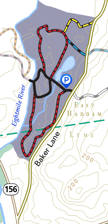
Patrell Preserve: 109 acres. Red Trail: 1 mile.
Parking: Baker Lane in East Haddam.
Detailed Trail Map and brochure.
Description: The Lyme Land Trust shares this property with East Haddam. The 0.3 mile paved trail section plus the bridge over the Eightmile River accommodates mobility-impaired nature lovers. The red trail follows more than 3000 feet of frontage on the Eightmile River. Horses and non-motorized bicycles are allowed. The Patrell Preserve is part of a larger East Haddam property called Chapal Farm Preserve. The Goodwin Trail traverses the East Haddam section of this preserve.
Pleasant Valley Preserve
Pleasant Valley Preserve: 235 acres. Trails: 3.85 miles (4 trails).
Parking: Macintosh Rd.
Map for Family Walk/Scavenger Hunt
Detailed Trail Map and brochure. Part of River to Ridgetop Preserves: Map of entire region.
Description: The Eightmile River flows through Pleasant Valley Preserve and is accessed by a spur of the red trail. The red trail and blue trail travel through a series of fields with cedar trees, birds, wildflowers and butterflies; a pine tree grove; and along the rim of a kettle hole. The yellow trail in Pleasant Valley rewards the hiker with a bench and a spectacular view after a moderate incline through mature woodland. Please note that part of the yellow trail ,where it crosses private property, is closed during hunting season in November and December.
Plimpton Preserve
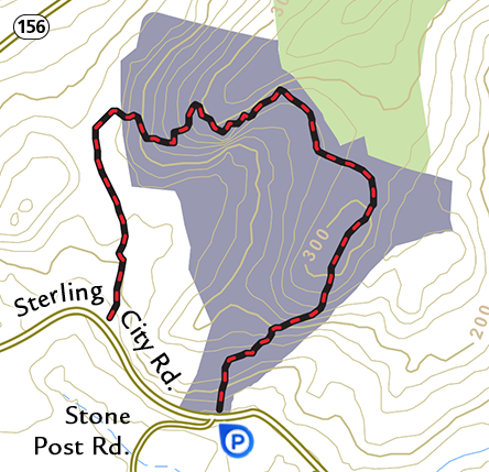
Plimpton Preserve: 80 acres. Red Trail: 1.75 miles loop with return on road.
Parking: pull off on Sterling City Rd. near Stone Post Rd. across from preserve entrance.
Detailed Trail Map and brochure.
Description: This preserve protects the view of the ridge line behind Tiffany Farms on Rte. 156. There are some steep hills on this lovely trail but the view at the overlook on the summit is worth the climb.
Ravine Trail
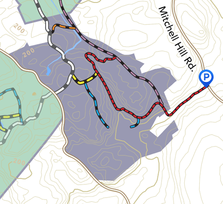
Ravine Trail: 98 acres. Trails: 1.8 miles ( 4 trails, 2 spurs).
Parking: Joshuatown Rd. (pull in at Selden Creek Preserve lot) or on Mitchell Hill Rd.
Detailed Trail Map and brochure. Hadlyme Hills trail network.
Description: The Ravine Trail red trail has a primeval feel as it travels through a deep hollow with steep ledges on either side. Be sure to visit dramatic overlooks of the beaver meadow on the blue trail. The red and purple trails are challenging with some steep hills and craggy terrain.
Honey Hill Preserve
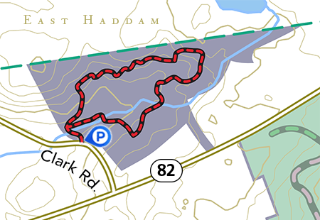
Honey Hill Preserve: 40 acres. Red Trail: 1-mile loop.
Parking: Clark Rd. approximately 200 yards from Rte. 82.
Detailed Trail Map and brochure.
Description: The loop trail winds through mature forest with a diversity of tree species. Linger on the bridge over a babbling brook.
Goodwin Trail
Goodwin Trail, Richard H. Goodwin Trail, Trail: 14-mile one-way.
Lyme Parking: On west side of Gungy Rd. for Lyme’s 1.7-mile segment through Hartman Park.
Detailed Trail Map and brochure.
Description: Follow the “G” blazes to traverse connecting trails through East Haddam, Salem, Lyme, and East Lyme, administered by the Eightmile River Wild & Scenic Coordinating Committee.
Riverside Preserve
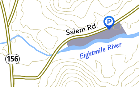
Riverside Preserve: 6 acres. Path: 600 feet. Trail: 300 feet.
Parking: Salem Rd. about 1/2 mile from Rte. 156.
Detailed Trail Map and brochure
Description: This preserve provides a small pavilion with a picnic table and beautiful views of the Eightmile River. There is a short loop path through a wildflower meadow. The white trail leads to the river.
Selden Creek Preserve
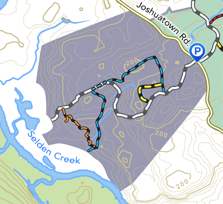
Selden Creek Preserve: 202 acres. Trails: 2.1 miles (4 trails).
Parking: lot on Joshuatown Rd. four miles from Rte. 156.
Detailed Trail Map and brochure. Hadlyme Hills trail network.
Description: At the end of the white and blue trails (0.8 miles one-way from the parking lot), the preserve offers spectacular cliff-top vistas of the wetlands and marshes of Selden Creek. The orange trail connects the overlooks and offers wonderful views. Check out the vernal pool on the yellow trail.
Selden Landing
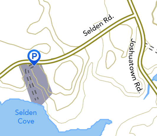
Selden Landing: 2.5 acres. Mowed paths.
Directions: Pull in along Selden Rd. near the sign.
Description: Great views from the bench on the rocky bluff make this a pleasant place to birdwatch or enjoy a picnic overlooking Selden Cove. Brackish tidal wetlands provide habitat for migratory bird species. The old driveway to the water is navigable by vehicles with 4-wheel drive and a high carriage for unimproved high-tide launch for small watercraft.
Slawson Preserve / Fehrer Preserve
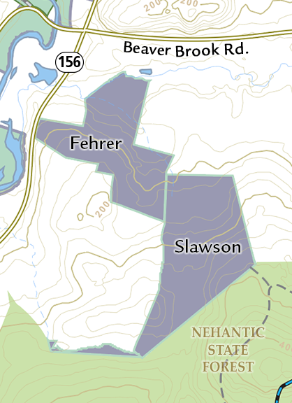
Slawson Preserve, 55 acres; Fehrer Preserve, 50 acres. No blazed trails, visitors welcome.
Access: Slawson Preserve can be accessed through Nehantic State Forest.
Description: Slawson preserve is a showcase for the creation of young forest habitat that benefits the New England cottontail rabbit and many other endangered species. The Lyme Land Trust has partnered with the State of CT and adjacent landowners to harvest mature trees in succession in order to offer a variety of habitats as the trees grow back.
Roaring Brook Preserve
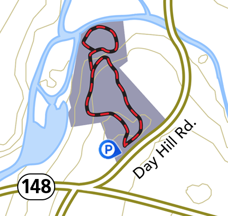
Roaring Brook Preserve: 7.5 acres. Rufus Barringer Interpretive Trail: 0.7-mile loop
Parking: Day Hill Rd., small pull-in lot just north of Hadlyme Public Hall.
Detailed Trail Map and brochure.
Description: This small gem offers an inclined path through a hemlock forest down to the cooling waters of the boulder-strewn Roaring Brook.
Hemlocks Preserve
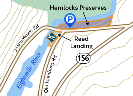
Hemlocks Preserve: 1 acre. No trails.
Parking: Pull-in along Joshuatown Rd.
Hemlocks Preserve, with 630 feet along the Eightmile River, provides access for water recreation and wildlife viewing, and parking for the small boat launch at the 0.1 acre Reed Landing, at the corner of Joshuatown and Old Hamburg Road.
Augur Preserve
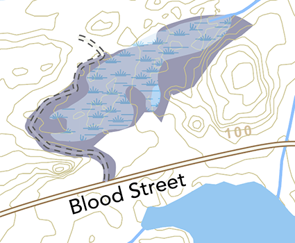
Augur Preserve: 30 acres. No trails.
Parking: Blood Street, driveway up to property for walking only. No designated parking.
Almost entirely swamp or pond depending on beaver activity and precipitation. There are no trails, however the dirt driveway along the western boundary provides a short walk and wildlife viewing.
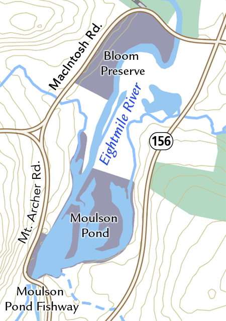
Bloom Preserve
Bloom Preserve: 10 acres. No Public Access
Parking: MacIntoch Rd. No designated parking
This property is restricted in order to provide a safe and workable space for a local organic farm to grow food and graze their animals. This is one of many community partnerships that we are proud to be developing here in Lyme.
Hand Smith Preserve
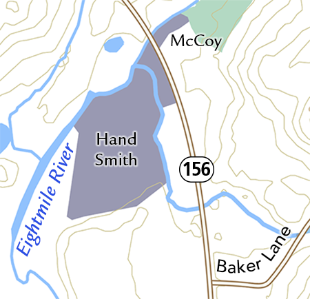
Hand Smith Preserve: 23 acres. No trails.
Parking: no designated parking, park on side of Rte. 156
This property is restricted in order to provide a safe and workable space for a local organic farm to grow food and graze their animals. This is one of many community partnerships that we are proud to be developing here in Lyme.
Along with the 1-acre McCoy property, about 1500 feet of Eightmile River frontage is protected. Walkers are welcome.
Idlewild Preserve
Idlewild Preserve: 43 acres. No trails.
Parking: Grassy Hill Rd., no designated parking
This preserve was donated to the Lyme Land Trust in 2020. There are no trails but walkers are welcome. This sanctuary for flora and fauna is an important link in a large wildlife corridor of open space.
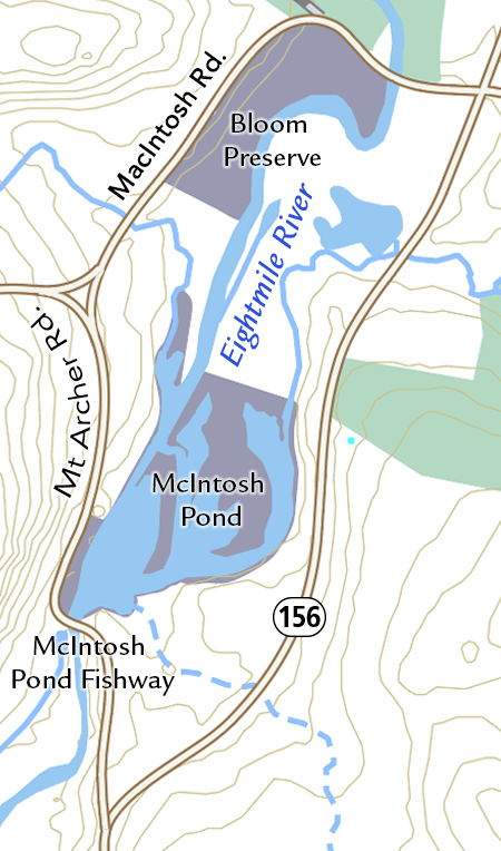
McIntosh Pond
McIntosh Pond and McIntosh Pond Fishway: 19 acres. No Trails.
Parking. Mt. Archer Rd., no designated parking.
The McIntosh Pond fish ladder is on private property. It allows migratory fish a passage over the dam for spawning in the protected waters of McIntosh Pond and beyond. Walkers are welcome to enjoy the views of the historic mill house, dam and the wildlife attracted to the pond.
Ram’s Horn Creek Preserve
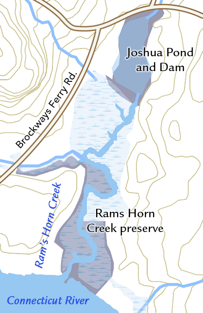
Ram’s Horn Creek Preserve: 8 acres. No Trails
Parking: No designated parking
Ram’s Horn Creek preserve is the Lyme Land Trusts first property, donated in 1968. A wonderful place to view wildlife, it is primarily tidal marshland along Rams Horn Creek, also known as Joshua Creek. The best way to access it is through kayak or canoe. The Land Trust acquired and restored Joshua Pond and Dam after the flood of 1982 washed the dam away.
Sterling City Preserve
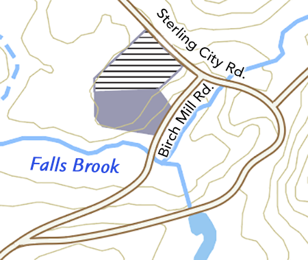
Sterling City Preserve: 6 acres. No public access.
Sterling City Rd. and Birch Mill Rd.
The open field is a conservation easement on private land.
Gillette Castle State Park
Gillette Castle State Park: 184 acres. Many trails
For map and more information.
Gillette’s Castle State Park is situated in Lyme and East Haddam. Besides the fascinating historic castle, there is an extensive trail system through mature forest, past geologic wonders with stunning vistas of the Connecticut River.
Nehantic State Forest
Nehantic State Forest: thousands of acres in Lyme and East Lyme. Many trails
For maps and more information. Please note the State maps are out-of-date and not reliable.
The Connecticut Forest and Parks Association maintains a reliable blue trail in the Lyme block.
Selden Neck State Park
Selden Neck State Park: 600 acre island. Unmarked trails
Accessible by boat only.
For map and more information.
Historical remains of a large quarry operation from the 19th century are evident. There are four primitive camping sites available by permit.
Moore Trail
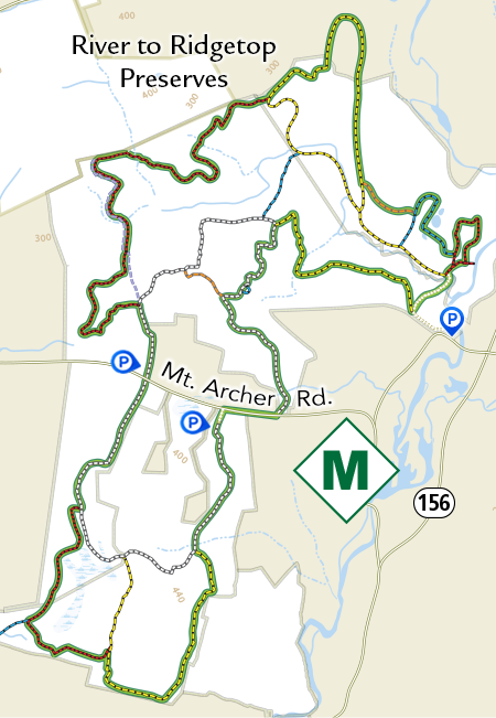
Moore Trail: George and Rosemary Moore Trail, 9-mile loop
Follow the “M” blazes through River to Ridgetop Preserves.
3-mile loop south of Mt Archer Rd. Start and return at Mt Archer Woods parking lot– an easy flat walk through mature forest and some wetlands with return on Mt Archer Rd.
6-mile loop north of Mt Archer Rd. Start and end at Jewett cemetery lot on Mt. Archer or lot on MacIntosh Rd. –a moderate walk through various habitats, with some hill climbs and rocky areas.
Detailed Trail Map and brochure.
Johnston Preserve
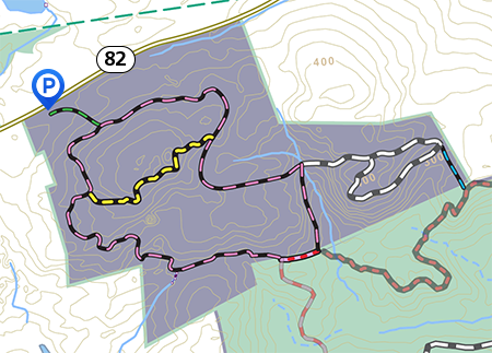
Johnston Preserve: 250 acres. Trails: 4 miles (3 trails, 2 spurs)
Parking: Rte. 82 - Johnston parking lot, 2 miles west of Rte. 82 and Rte. 156 intersection.
Detailed Trail Map and brochure. Part of River to Ridgetop Preserves: Map of entire region.
Description: The Johnston Preserve has fascinating geologic features, from deep hollows to ridges with dramatic outcroppings and ledges. The white trail gently climbs to breathtaking seasonal overlooks. The yellow trail traverses North Woods Hill, the highest point in Lyme.
Susan and Frederick Hilles Preserve
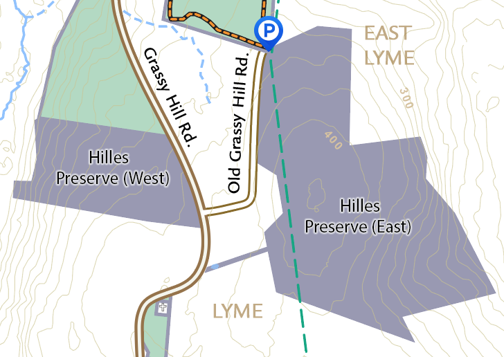
Susan and Frederick Hilles Preserve: 180 acres. No trails.
Grassy Hill Rd. and Old Grassy Hill Rd. Parking: Beebe Preserve lot.
This preserve was given to the Lyme Land Trust by the Hilles family in 2021. It has no trails but walkers are welcome except during deer firearm season, Monday through Friday, Nov 14 to Dec 26, when the preserve is closed for hunting. Wear bright colors during all hunting seasons from Sept 15 to Jan 31.
This property is managed for wildlife and is an important link in a corridor of open space extending from Lyme into East Lyme.
Reed Landing
Reed Landing: 0.1 acre. No trails
Park at Hemlocks Preserve parking area. Short term parking allowed along the road for boat launching.
Reed Landing provides water access for wildlife viewing, fishing, and small watercraft. Two native plant rain gardens were installed in 2022 and 2023. To learn more about the rain gardens, visit: https://www.lymelandtrust.org/reed-landing-meadow/